

Latest News
 Water conservation measures in place for Newbury residents
 Claremont plans $1.3 million upgrade for Broad Street sidewalks and crossings
 Police: Canaan man found dead with stab wound
 ‘Who the hell are we as a state?’: John Broderick says new NH law guts, politicizes fund for youth detention center abuse victims
 NH teen pleads guilty to 2022 triple murder of sister-in-law and two nephews
 Editorial: Vermont should encourage local education reforms
 A Q&A with New Hampshire’s state epidemiologist, Dr. Benjamin Chan
 Students overcome challenges to earn diplomas from Vermont Adult Learning

Upper Valley stove manufacturer hurt by tariffs, end of tax breaks
New Hampshire’s only manufacturer of wood stoves says it is being buffeted by costs and confusion from two different directions — tariffs and taxes — that will hurt sales and may lead to layoffs.

Royalton bridge replacement plan won’t include temporary span
ROYALTON — Despite the frustration of some residents, the Selectboard voted 3-2 last week to proceed with construction of a permanent span at Fox Stand Bridge, also known as Royalton Hill Bridge.
Most Read
 Head-on crash in Hartland leaves one dead
 Newport property maintenance firm closes amid embezzlement allegations
 With neo-Nazi rally in Concord, extremism and hate are on the rise in New Hampshire
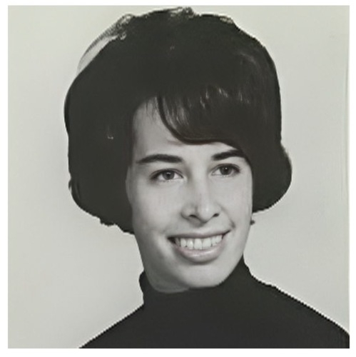
 A Life: Marie Doyle ‘was just so kind all the time’
Editors Picks
 Woodstock, Windsor schools join collaboration that aims to improve special education and save costs
 Tai chi and chair yoga help seniors stay active and social
 Editorial: NH Legislature shows disregard for child welfare
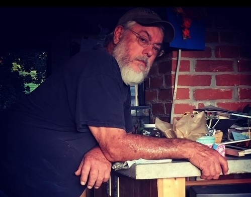
 A Life: Kathy Hoyt was a ‘force in Vermont politics for years’

Sports

Test shows elevated level of E. coli at Canaan Street Lake beach
By CLARE SHANAHAN
 Rugby club in Upper Valley unites diverse group through sport and camaraderie
 Concord City Council votes to buy rail corridor with a ”heavy heart,’ threatening local rail bike business
 Hiking: Plainfield native conquers Long Trail in record time
 Over Easy: Too hot, too high, too much
Opinion

Editorial: NH betrays victims of YDC abuse
While the MAGA-verse is all atwitter about the Epstein sex trafficking files, its New Hampshire wing is further victimizing hundreds of people who suffered horrendous sexual and physical abuse while in state custody as children. Republicans in the Legislature, Gov. Kelly Ayotte and Attorney General John Formella are all implicated. This is unconscionable, at least to anyone who has a conscience.
 Editorial: Questions for warm weather consideration
 Editorial: Grafton County officials' change of party raises questions
 Editorial: An education ruling that NH will disobey, again
 Editorial: Shelter project shows healthy approach to housing crisis

Your Daily Puzzles
An approachable redesign to a classic. Explore our "hints."
A quick daily flip. Finally, someone cracked the code on digital jigsaw puzzles.
Chess but with chaos: Every day is a unique, wacky board.
Word search but as a strategy game. Clearing the board feels really good.
Align the letters in just the right way to spell a word. And then more words.
Photos

Teamwork in North Hartland
NORTH HARTLAND — Phoenix Cook, left, of Hartland, and Emily Pritchard, of South Royalton, react to the damaged camper tire they had just taken off Cook’s fifth-wheel camper.
 Plainfield’s profitable partners
 Ready to roll in Hartford
 Parking lot play time
 Taking their dog for a swim in Mascoma Lake
e-Edition
Arts & Life

Handmade harp in Lebanon
LEBANON — Stephen Ryan, of Springfield, N.H., carries his daughter Joanna’s Paraguayan harp back to their vehicle after a lesson at the Upper Valley Music Center in downtown Lebanon on Friday.
 Abenaki and Indigenous Peoples Honoring Day returns to Lyman Point Park
 Art Notes: ‘The Cottage’ brings farcical fun to New London Barn Playhouse
 ‘This isn’t really a home’: As some unhoused Vermonters turn to sleeping in vehicles, advocates push for long-term solutions
 Brook trout populations spike after Vermont program adds wood to streams
Obituaries
 Raymond Merrihew
Lebanon, NH - Raymond G. Merrihew, 83, of Lebanon, NH, passed away on August 17, 2025, at the VA Medical Center in White River Junction, VT. Ray was born in Lebanon, NH, to Thomas Merrihew and Ruth Strong, and graduated from Lebanon Hi... remainder of obit for Raymond Merrihew
 Janet Aronson
Hanover, NH - JANET ARONSON: She passed away with her daughters at her side on Wednesday, August 20, 2025. Loving mother of Leah Matthew (Michael Matthew) and Lynn Garfinkel (Patrick Williams). Cherished daughter of the late Harry and D... remainder of obit for Janet Aronson
 Ervin E. Needham
South Strafford, VT - Ervin Edward "Buster" Needham, 76 of South Stafford, passed away on August 21, 2025 at Dartmouth Hitchcock Medical Center. Born on May 4, 1949 to Melvin Edward and Maude Abigail Russell Whitaker Needham. He was... remainder of obit for Ervin E. Needham
 Kenneth David Parmenter
Bradenton, FL - Kenneth David Parmenter, 62, of Bradenton, FL, passed away peacefully on August 12, 2025, surrounded by his loving family, following complications from diabetes. Born in Worcester, MA, Ken was the son of Phillip Parment... remainder of obit for Kenneth David Parmenter